
This essay reviews the courses (tracks) and anatomy of some of the deadliest storms worldwide from roughly 1725–2025: how they formed, how and why they followed the tracks they did, why they caused such catastrophic loss of life, and what patterns (ocean basins, steering flows, coastal geography, tide timing, human vulnerability) repeat across events. I focus on representative, well-documented disasters (the Great Hurricane of 1780, the 1900 Galveston hurricane, the 1928 Okeechobee hurricane, the major Bay-of-Bengal cyclones including Bhola 1970 and the 1991 cyclone, Cyclone Nargis 2008, and Super Typhoon Haiyan 2013) and draw broader lessons about storm courses and fatal outcomes.
1. How to read a storm’s “course” — basic anatomy and steering physics
A tropical cyclone’s course (track) is the result of:
- Formation region and season: most form in particular ocean basins where sea-surface temperatures, vertical wind shear, and humidity favor development — e.g., the Bay of Bengal (deadly cyclones for Bangladesh/Myanmar), the Caribbean/Atlantic (historic hurricanes), and the Western North Pacific (powerful typhoons). Wikipedia
- Steering flow: large-scale winds (trade winds, subtropical ridges, monsoon troughs, midlatitude troughs) steer storms. A strong mid-latitude trough can pull storms poleward; a persistent subtropical ridge can force them westward into coastlines. Wikipedia
- Ocean heat and intensification: warm, deep water allows rapid intensification. When a storm encounters warm continental shelf waters and favorable shear it can strengthen before landfall, increasing surge/wind damage. Wikipedia+1
- Coastal geometry and tide timing: shallow, funnel-shaped bays (e.g., the northern Bay of Bengal, the Irrawaddy Delta, Galveston Bay) amplify storm surge. Landfall at high tide makes surge effects dramatically worse. Wikipedia+1
- Human geography & preparedness: densely populated lowlands, poor housing, lack of shelters or warnings, and social/political obstacles to evacuation multiply loss of life. Many of the deadliest storms struck densely populated, low-lying deltas or islands with limited warning or capacity to evacuate. Wikipedia+1
These five factors (formation region, steering flow, intensification, coastal geometry/tide, human vulnerability) explain why certain storm tracks are disproportionately lethal.
2. Case studies (storm, year, countries, course summary, why so deadly)
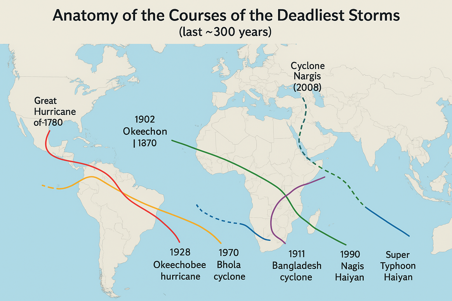
Great Hurricane of 1780 — Caribbean (October 1780)
Countries/areas: Barbados, Martinique, Saint Lucia, Sint Eustatius, Puerto Rico (Lesser Antilles).
Estimated deaths: ~22,000–30,000 (deadliest Atlantic hurricane on record).
Course & anatomy: The storm swept across the Lesser Antilles from east to west in early–mid October 1780, likely intensifying rapidly as it crossed warm Caribbean waters and striking islands directly. Detailed meteorological records are scarce, but contemporary reports place a powerful westward-moving Cat-5 event crossing Barbados and Martinique before affecting other islands. The combination of wooden housing, confined harbors, and the islands’ exposure to a westward-moving core of a major hurricane produced catastrophic destruction. Wikipedia+1
Why so deadly: little warning, construction not cyclone-resilient, and ships and ports destroyed — island populations had minimal places to shelter from hurricane-force winds and surge. Wikipedia
Country: United States (Texas).
Estimated deaths: commonly cited ~6,000–12,000 (many sources put ~8,000).
Course & anatomy: The hurricane tracked northwest across the Caribbean and Gulf of Mexico and struck Galveston Island on 8 September 1900. A destructive storm surge inundated the low, barrier-island city; the city had little in the way of storm defenses at the time. Wikipedia+1
Why so deadly: Galveston was a low-lying barrier island with a dense population and no seawall or effective evacuation plan in 1900. The storm surge and powerful winds destroyed most structures, causing massive fatalities. The disaster later drove major engineering responses (seawall, raising the island). arcgis.com
1928 Okeechobee hurricane — Caribbean, Puerto Rico, Florida (Lake Okeechobee)
Countries/areas: Puerto Rico, Bahamas, United States (Florida; Lake Okeechobee region).
Deaths: at least ~4,100 overall (estimates vary; ~2,500+ in U.S. alone; combined totals often cited ≈4,100).
Course & anatomy: Struck Puerto Rico as an extremely intense hurricane (Category 5), then moved across the Bahamas and made landfall on Florida’s east coast near Lake Okeechobee. Heavy rainfall and storm surge caused lake overflow (water surge flooding into surrounding lowlands). Wikipedia+1
Why so deadly: the storm pushed lake water into farming communities and migrant worker camps around Lake Okeechobee, where many houses were low and vulnerable; warnings and communications were limited. The geography of the lake and low-lying sugarcane plantations amplified the flood impact. Wikipedia+1
1970 Bhola cyclone — East Pakistan (today’s Bangladesh) and West Bengal, India
Countries: East Pakistan (now Bangladesh) and India (West Bengal).
Deaths: widely estimated 300,000–500,000 (deadliest tropical cyclone on record).
Course & anatomy: Bhola formed over the Bay of Bengal, tracked north-northwest, and made landfall on the Ganges Delta on 12 November 1970. A very large storm surge flooded extensive, extremely low-lying delta islands and coastal villages. Wikipedia
Why so deadly: the Ganges–Brahmaputra delta is extraordinarily low and densely populated; many inhabitants lived in simple housing with minimal access to high ground. A huge storm surge coinciding with tidal conditions inundated entire islands. Political failures in warning and relief compounded the death toll and had major political consequences. Wikipedia
1991 Bangladesh cyclone (April 1991) — Bangladesh & NE India
Countries: Bangladesh (Chittagong region, many coastal islands), India, Myanmar.
Deaths: ~138,000–140,000 (often cited ~138,000).
Course & anatomy: A powerful cyclone developed over the Bay of Bengal and accelerated northeastwards, making landfall on the southeastern Bangladesh coast near Chittagong around high tide with a ~6-7 m storm surge. The cyclone tracked inland into northeastern India and Myanmar, causing extensive flooding and wind damage. Wikipedia+1
Why so deadly: massive surge, high tides, densely populated coastal islands, and insufficient sheltering/evacuation capacity; rapid intensification and timing with tidal cycle worsened outcomes. Subsequent Bangladeshi investments in shelters and warning systems have reduced mortality from comparable storms since then. PubMed+1
Cyclone Nargis (2008) — Myanmar (Burma) and Bangladesh coasts
Country: Myanmar (Irrawaddy/Delta region), Bangladesh, India.
Deaths: official/PDNA combined figures sum high; totals of ~84,537 officially, with other tallies/estimates and missing people bringing consolidated counts to ~138,000 in some reports.
Course & anatomy: Nargis formed in the central Bay of Bengal, moved slowly northwestward then eastward and then ashore in the Irrawaddy Delta on 2 May 2008 at peak intensity. A large storm surge propagated across the wide, shallow delta, inundating villages far inland. Wikipedia+2GFDRR+2
Why so deadly: the Irrawaddy Delta is extremely vulnerable — wide, flat, and densely settled — and the political context impeded relief and external aid early on. The storm surge combined with high tide and the region’s low elevation produced massive inundation; failures in timely mass evacuation and distribution of shelter contributed. Wikipedia+1
Super Typhoon Haiyan (Yolanda) — Philippines (2013)
Country: Philippines (Leyte/Tacloban region and many islands).
Deaths: commonly cited ~6,000–6,300 direct deaths; millions displaced; enormous destruction.
Course & anatomy: Haiyan developed in the Western North Pacific, underwent extreme intensification over very warm ocean, and struck the central Philippines (Leyte Gulf/Tacloban area) on 8 November 2013 with exceptionally strong winds and a massive storm surge up narrow inlets and bays. Its track was roughly west/northwest into the archipelago, with the surge funneled into coastal bays. Wikipedia+2sciencedirect.com+2
Why so deadly: extremely high wind speeds and a multi-meter storm surge in confined bays (Tacloban’s coastal geometry amplified surge), combined with population density, damaged communications, and destroyed local resilience and shelters — plus the suddenness and scale of surge in low-lying coastal communities. sciencedirect.com+1
3. Common track patterns that produce extremely high fatalities
Across these cases certain track/geometry patterns repeat:
- Bay of Bengal northward tracks into large river deltas (Bhola 1970, Bangladesh 1991, Nargis 2008): storms that track northward from the central Bay of Bengal into very shallow, funnel-shaped delta coasts generate very large surges that penetrate far inland. The Bay of Bengal’s bathymetry and the long shallow shelf amplify surge. Wikipedia+2Wikipedia+2
- Barrier-island or embayment landfalls at high tide (Galveston 1900, parts of the Caribbean in 1780; Haiyan’s funneling into Leyte Gulf): narrow bays and inlets can concentrate surge; islands with low elevation are especially vulnerable. Timing at high astronomical tide or spring tide multiplies inundation depth. arcgis.com+2Wikipedia+2
- Rapid intensification just prior to landfall over warm, deep waters (Haiyan, Bay-of-Bengal storms): this reduces available lead time for evacuation and raises surge/wind hazard at landfall. Wikipedia+1
- Storms that travel slowly or stall nearshore: prolonged onshore winds and sustained surge/rainfall can deepen flooding (seen in some Bay of Bengal cases and other events). Slow movement also increases rainfall totals. Wikipedia+1
4. Why some basins produce more catastrophic death tolls than others
- Population & poverty density near coasts: the northern Bay of Bengal and some Caribbean islands historically had dense, low-lying populations with vulnerable housing—leading to higher fatalities when surge occurred. Wikipedia+1
- Coastal shelf and bathymetry: shallow shelves amplify surge more than steep shelves. The Bay of Bengal’s geometry makes surges larger than many open-ocean coastlines. Wikipedia
- Warning systems & governance: by the late 20th and early 21st centuries warning systems and shelters reduced deaths for many storms — Bangladesh’s cyclone preparedness improvements, for example, cut mortality from comparable storms after 1991 — but governance failures (e.g., restricted access after Nargis) can worsen outcomes. PubMed+1
5. Lessons from the tracks — mitigation tied to understanding courses
- Map the likely tracks for each basin and prioritize shelters along those tracks: knowing that storms forming in a certain zone will often be steered into a delta (e.g., central Bay of Bengal → Bangladesh/Myanmar), governments can place robust shelters and evacuation routes where surge will be worst. Wikipedia+1
- Protect vulnerable coastal geomorphologies: seawalls, raised berms, mangrove restoration (natural buffers), and dike systems (e.g., Lake Okeechobee dike works after the 1920s storms) reduce impacts when tracks put storm surge risk onto populated areas. weather.gov+1
- Improve rapid intensity forecasting: when storms can intensify rapidly right before landfall, warnings and pre-positioned evacuation plans save lives. Haiyan and other fast-intensifiers show the need for modern forecast systems and rapid outreach. Wikipedia+1
6. Short annotated list of some of the deadliest storms (quick reference)
- Great Hurricane of 1780 — Caribbean islands, Oct 1780 — est. 22,000–30,000 deaths. Wikipedia+1
- 1900 Galveston hurricane — Galveston, Texas, 8 Sep 1900 — est. ~6,000–8,000+ deaths. Wikipedia+1
- 1928 Okeechobee hurricane — Puerto Rico → Florida (Lake Okeechobee), Sep 1928 — est. ~4,100+ deaths (regional totals vary). Wikipedia
- 1970 Bhola cyclone — East Pakistan (now Bangladesh), 12 Nov 1970 — est. 300,000–500,000 deaths (deadliest tropical cyclone recorded). Wikipedia
- 1991 Bangladesh cyclone — 22–30 Apr 1991 — est. ~138,000–140,000 deaths. Wikipedia+1
- Cyclone Nargis (2008) — Myanmar (Irrawaddy Delta), 2 May 2008 — official PDNA & consolidated estimates widely report totals ranging from ~84,000 to broader tallies near 138,000 (dead and missing combined). Wikipedia+1
- Super Typhoon Haiyan (2013) — Philippines (Tacloban/Leyte), 8 Nov 2013 — ~6,000+ deaths and massive displacement. Wikipedia+1
(A broader compiled list of deadliest tropical cyclones and counts is available in international storm databases and compilations.) Wikipedia
7. Final synthesis — the anatomy of deadly courses
- The deadliest tracks share: (a) approach from warm open waters into shallow, funneling coastal geometry (deltas, enclosed bays), (b) landfall near high tide, (c) rapid intensification close to landfall, and (d) hitting densely populated, low-elevation areas with limited sheltering. When these factors coincide, even a relatively small storm can cause thousands of deaths; when they combine with very powerful storms (Cat-4/5) the toll can be catastrophic (Bhola, 1780 Hurricane). Wikipedia+2Wikipedia+2
- Reducing mortality from future storms requires forecast improvements, place-based coastal defenses and nature-based buffers, early-warning systems and evacuation shelters placed along historically vulnerable tracks, and addressing social/governance obstacles that block timely relief. The historical record of storm tracks and impacts is a guidebook: where a basin funnels surge (e.g., northern Bay of Bengal, Leyte Gulf), investments in physical and social resilience yield the largest life-saving returns.


Be First to Comment