
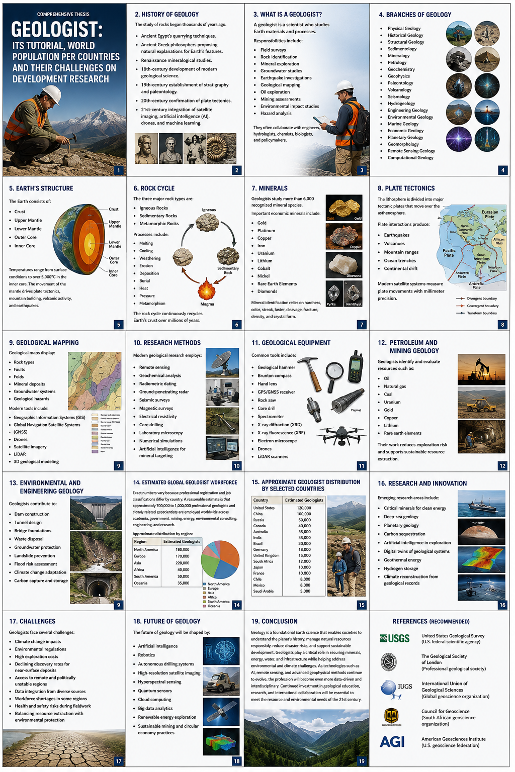
A Comprehensive Thesis and Tutorial on the Geologist’s Discipline, World Population by Country, and the Challenges Facing Development Research
Abstract
This thesis and tutorial presents an integrated study of three interlocking domains: the discipline and practice of geology; the current distribution of the world’s human population by country; and the structural challenges confronting development research in a resource-constrained, demographically diverse world. Part I is a practical tutorial on geology. Part II presents an evidence-based account of global population distribution in 2026. Part III synthesises the first two parts by examining how geological endowment, population pressure, and urbanisation jointly shape the challenges facing development research today, with particular attention to Sub-Saharan Africa and South Africa.
The unifying thesis: population and development cannot be understood in isolation from the physical Earth on which they unfold. A geologist’s training is not a peripheral technical specialism but a foundational input into serious development planning.
Part I — Geology: Foundations and Tutorial
1.1 What Is Geology?
Geology is the scientific study of the Earth — its materials, structures, processes, and 4.6-billion-year history. It asks how rock, mineral, and sediment form; how continents move and mountains rise; how water, ice, and wind reshape the land; and how the planet’s deep interior drives surface phenomena such as earthquakes, volcanoes, and mineral wealth accumulation.
For a working geologist, the discipline is both theoretical and deeply practical. Theoretical geology builds frameworks — plate tectonics, the rock cycle, stratigraphy, geochronology. Applied geology takes those frameworks into the field to locate water, energy, and mineral resources, assess hazards, and guide safe construction.
1.2 The Branches of Geology
Modern geology has diversified into numerous specialisms. The table below summarises the principal branches a student or early-career geologist encounters. Copy table
| Branch | Core Focus | Typical Application |
|---|---|---|
| Mineralogy | Composition, structure, properties of minerals | Resource exploration, materials science |
| Petrology | Origin and classification of rocks | Reservoir and ore characterisation |
| Structural Geology | Deformation — folds, faults, fractures | Earthquake risk, tunnel/mine design |
| Stratigraphy | Layering and sequencing through time | Correlating basins, dating events |
| Sedimentology | Formation and transport of sediment | Groundwater, hydrocarbon reservoirs |
| Geomorphology | Landform evolution at the surface | Flood risk, coastal management |
| Hydrogeology | Movement and storage of groundwater | Water supply, contamination control |
| Economic Geology | Location and viability of mineral deposits | Mining investment decisions |
| Engineering Geology | Ground conditions for construction | Foundations, slope stability |
| Volcanology / Seismology | Volcanic and seismic activity | Hazard forecasting, land-use planning |
| Geochronology | Dating rocks and events | Establishing Earth’s timescale |
| Environmental Geology | Human interaction with geological systems | Land rehabilitation, waste containment |
1.3 The Geologist’s Toolkit and Field Methods
Despite the growth of remote sensing and digital modelling, geology remains a field-first discipline:
- Rock hammer and chisel — obtaining fresh, unweathered rock samples.
- Hand lens (10×) — identifying mineral grains and rock texture in the field.
- Compass-clinometer — measuring strike and dip of rock layers.
- Acid bottle — the classic fizz test for carbonate minerals.
- Field notebook and geological map base — recording spatially referenced observations.
- GNSS unit — precise field positioning.
- Core drilling and sampling equipment — subsurface investigation beyond the outcrop.
Contemporary geology also draws on satellite and drone remote sensing, seismic reflection surveys, X-ray diffraction and electron microscopy, mass spectrometry for isotopic dating, and increasingly machine-learning-assisted interpretation of large geological datasets.
1.4 Fieldwork, Training, and the Career Pathway
The typical pathway begins with an undergraduate degree in geology or a related Earth science field, followed by supervised field mapping. Many geologists then pursue postgraduate specialisation toward research, academia, or technical exploration roles.
- Undergraduate study: mineralogy, structural geology, stratigraphy, supervised field mapping.
- Entry-level fieldwork: logging core, assisting on exploration or engineering site investigations.
- Specialisation: postgraduate study or on-the-job progression into a chosen branch.
- Professional registration: accumulating supervised experience toward chartered/registered status.
- Senior practice: independent project leadership, certification, hazard sign-off, or policy advisory roles.
In South Africa, practising geologists typically register with SACNASP; internationally, equivalents include the American Institute of Professional Geologists and the Geological Society of London’s Chartered Geologist designation.
1.5 Geology’s Relationship to Society and Policy
Geology’s findings translate directly into decisions affecting millions of people — from borehole sustainability to seismic building codes to national mining royalty policy. This is a quiet but constant input into national development planning, a theme developed fully in Part III.
“The rock record is the only complete archive of the planet’s past; every development plan that ignores it is building on an incomplete map.”
1.6 The Rock Cycle and Geological Time
The rock cycle describes the continuous transformation of Earth materials between igneous, sedimentary, and metamorphic states. Igneous rock forms as magma cools; weathering breaks rock into sediment that becomes sedimentary rock; heat and pressure transform either into metamorphic rock; sufficient heat melts rock back into magma.
The geological timescale is vast: Earth formed ~4.6 billion years ago, complex animal life emerged ~540 million years ago, and modern humans have existed for only ~300,000 years — too thin a sliver to register on most timescale diagrams.
1.7 Plate Tectonics: The Unifying Theory
Plate tectonics holds that Earth’s rigid outer shell is broken into plates moving over the ductile asthenosphere, driven by mantle convection. Divergent boundaries create new crust; convergent boundaries build mountains or subduction zones; transform boundaries (e.g. the San Andreas Fault) generate major earthquake hazard. This single framework explains the global distribution of earthquakes, volcanoes, mountain belts, and many mineral deposits.
1.8 Minerals and Rocks: A Working Vocabulary
A mineral is a naturally occurring, inorganic solid with defined composition and crystal structure. A rock is any naturally occurring aggregate of one or more minerals.
| Rock Type | Formation Process | Common Examples |
|---|---|---|
| Igneous | Cooling/solidification of magma or lava | Granite, basalt, obsidian |
| Sedimentary | Compaction and cementation of sediment | Sandstone, limestone, shale |
| Metamorphic | Transformation under heat and pressure | Marble, slate, gneiss |
1.9 Natural Hazards and Risk Assessment
Hazard assessment differs from forecasting: geologists map where events are geologically probable and at what approximate magnitude, informing building codes, land-use zoning, and insurance pricing.
| Hazard | Geological Driver | Typical Mitigation |
|---|---|---|
| Earthquake | Stress release along active faults | Seismic codes, fault-setback zoning |
| Volcanic eruption | Magma ascent at active centres | Exclusion zones, monitoring, evacuation |
| Landslide | Slope instability | Stabilisation, land-use restriction |
| Flood | River/coastal inundation | Floodplain mapping, levees |
| Subsidence / sinkhole | Collapse of underground voids | Ground investigation, void-filling |
| Tsunami | Seafloor displacement | Early-warning systems, setback zoning |
Part II — World Population by Country
2.1 Global Population Overview, 2026
As of 2026, the world’s population stands at approximately 8.2 billion people, growing at roughly 0.9% per year — about 70 million people annually — a multi-decade deceleration from the 2%+ peak of the late 1960s. Growth is shifting decisively toward South Asia and Sub-Saharan Africa while Europe and East Asia enter population decline.
India surpassed China as the most populous nation in 2023; by 2026 the gap exceeds 35 million people. China’s population is now in outright decline, recording more deaths than births since 2022, with fertility near 1.0 births per woman — well below the 2.1 replacement rate.
2.2 The Twenty Most Populous Countries
Copy table
| Rank | Country | Population (approx.) | Region |
|---|---|---|---|
| 1 | India | 1.45 billion | South Asia |
| 2 | China | 1.41 billion | East Asia |
| 3 | United States | 340 million | North America |
| 4 | Indonesia | 284 million | Southeast Asia |
| 5 | Pakistan | 241 million | South Asia |
| 6 | Nigeria | 233 million | West Africa |
| 7 | Brazil | 218 million | South America |
| 8 | Bangladesh | 175 million | South Asia |
| 9 | Russia | 144 million | Europe/Asia |
| 10 | Ethiopia | 132 million | East Africa |
| 11 | Mexico | 129 million | North America |
| 12 | Japan | 123 million | East Asia |
| 13 | Philippines | 118 million | Southeast Asia |
| 14 | Egypt | 116 million | North Africa |
| 15 | DR Congo | 112 million | Central Africa |
| 16 | Vietnam | 101 million | Southeast Asia |
| 17 | Iran | 92 million | West Asia |
| 18 | Turkey | 88 million | West Asia |
| 19 | Germany | 84 million | Europe |
| 20 | Thailand | 72 million | Southeast Asia |
South Africa records approximately 63 million people, ranking just outside the global top twenty and third-most populous on the African continent after Nigeria and Ethiopia.
2.3 Regional Distribution of Population
| Region | Approx. Share | Trajectory |
|---|---|---|
| Asia | ~58% | Growth slowing; China declining, South/SE Asia still expanding |
| Africa | ~18% | Fastest-growing region; young age structure |
| Europe | ~9% | Contracting; below-replacement fertility |
| Latin America & Caribbean | ~8% | Approaching stabilisation |
| North America | ~5% | Modest, migration-driven growth |
| Oceania | ~0.5% | Slow growth, small absolute base |
2.4 The Demographic Transition Model
- Stage 1 — Pre-transition: high birth and death rates, slow growth. Historically universal.
- Stage 2 — Early transition: death rates fall sharply, birth rates stay high — rapid growth. Much of Sub-Saharan Africa today.
- Stage 3 — Late transition: birth rates begin falling. Nigeria, Pakistan, parts of South Asia.
- Stage 4 — Post-transition: low birth and death rates, stabilising growth. US, much of Latin America.
- Stage 5 — Population decline: below-replacement fertility, contracting population absent migration. China, Japan, Russia, most of Europe.
2.5 Population Density and Physical Geography
Bangladesh, at over 1,180 people per km², is the most densely populated large nation — a consequence of its fertile but flood-prone deltaic plain. Russia, the largest country by land area, has one of the lowest overall densities among major nations, concentrated in a narrow western band. Human settlement has always tracked the geological map: fertile alluvial plains, reliable freshwater, coastal trade access, and hazard-free temperate climates.
2.6 Age Structure: Youth Bulges and Ageing Societies
Countries in early demographic transition carry a youth bulge that, managed well, produces a demographic dividend — the engine behind East Asia’s rise from the 1960s–1990s. Japan, Germany, Italy, and increasingly China face the inverse: a shrinking working-age population supporting a growing retired population, straining pensions and healthcare.
2.7 Migration as a Population Variable
The United States and much of Western Europe now grow primarily through net migration rather than natural increase. For sending countries, sustained emigration of skilled workers can offset the fiscal benefits of a youth bulge (brain drain). Migration corrects labour shortfalls far faster than fertility policy, which takes upwards of two decades to affect the working-age population.
2.8 Data Quality and Measurement Challenges
Countries with recent censuses and strong civil registration (Europe, North America, East Asia) produce estimates accurate to within ~1%. Many lower-income countries rely on projections from outdated censuses. The UN publishes explicit uncertainty intervals for this reason, and organisations like World Economics grade country population data quality from “as good as it gets” to “extremely poor quality.”
2.9 Extended Country Rankings (21–40)
| Rank | Country | Population | Region |
|---|---|---|---|
| 21 | United Kingdom | 69M | Europe |
| 22 | Tanzania | 68M | East Africa |
| 23 | France | 66M | Europe |
| 24 | South Africa | 63M | Southern Africa |
| 25 | Italy | 59M | Europe |
| 26 | Kenya | 58M | East Africa |
| 27 | Myanmar | 56M | Southeast Asia |
| 28 | Colombia | 53M | South America |
| 29 | South Korea | 51M | East Asia |
| 30 | Uganda | 50M | East Africa |
| 31 | Sudan | 49M | North Africa |
| 32 | Spain | 48M | Europe |
| 33 | Algeria | 47M | North Africa |
| 34 | Iraq | 46M | West Asia |
| 35 | Argentina | 46M | South America |
| 36 | Afghanistan | 42M | South Asia |
| 37 | Yemen | 41M | West Asia |
| 38 | Canada | 40M | North America |
| 39 | Poland | 38M | Europe |
| 40 | Morocco | 38M | North Africa |
Part III — Challenges Facing Development Research
3.1 Geological Endowment and Resource Distribution
A nation’s geological endowment — minerals, hydrocarbons, groundwater, arable soil — is fixed by processes unfolding over hundreds of millions of years yet shapes development options today. South Africa’s Bushveld Complex or the DRC’s copper-cobalt belt illustrate both the opportunity and the governance burden: extractive wealth can fund development, or entrench the “resource curse” where governance is poor.
3.2 Urbanisation, Geohazards, and Infrastructure
More than half of humanity now lives in cities, projected to exceed two-thirds by 2050, with almost all net increase in Africa and Asia. Rapid, often informal urbanisation collides with geological reality: cities expand onto floodplains, unstable slopes, and reclaimed coastal land — exactly the terrain a geologist would flag as high-risk. Lagos, Jakarta, and Dhaka illustrate the pattern.
3.3 Water, Minerals, and Sustainable Development
Groundwater supplies roughly half the world’s drinking water and most irrigation in water-stressed regions, yet is frequently extracted faster than it is replenished. The renewable energy transition is itself mineral-intensive, requiring vastly increased lithium, cobalt, copper, and rare earth supplies — a geological supply constraint development modelling must incorporate realistically.
3.4 Climate Change as a Development Multiplier
Climate change intensifies and redistributes existing geological hazards rather than creating new categories. Sea-level rise accelerates coastal erosion and saline intrusion; shifting rainfall alters recharge rates and slope stability, raising landslide risk in the Himalayan foothills and parts of East Africa. Adaptation planning cannot be separated from geological and hydrogeological assessment.
3.5 Case Study: Sub-Saharan Africa and South Africa
Sub-Saharan Africa converges all three challenge areas: the world’s fastest-growing region demographically, rich in largely unexploited mineral endowment, yet facing acute infrastructure backlogs and geohazard/water pressure in sub-regions. South Africa holds mature mining and geoscience institutions (Council for Geoscience, SACNASP) but a documented infrastructure backlog in water, transport, and energy — a challenge of translating existing scientific capacity into faster, coordinated delivery.
“Africa’s demographic dividend and its mineral endowment are two sides of the same development opportunity; realising either without sound geoscience and coordinated infrastructure planning risks squandering both.”
3.6 Toward a Methodology: Integrating Geoscience into Development Research
Development research design should incorporate geoscientific screening as a standard early input, structured around four questions:
- Resource question: What resources does the geology actually support, at what confidence level?
- Hazard question: What geohazards affect this site, and how does exposure compare with codes?
- Capacity question: Does population density/age structure match the proposed development pathway?
- Trajectory question: How do climate and demographic projections interact with the geological baseline over the planning horizon?
3.7 Data and Funding Gaps in Development Research
Countries where development research is most urgently needed are frequently those where baseline data — census, geological mapping, hydrogeological coverage — is thinnest. A second constraint is a funding mismatch: geological and demographic processes unfold over decades, yet research budgets are typically committed in one-to-three-year cycles.
3.8 Summary Recommendations for Practitioners
- Commission geological and hydrogeological baseline data at the earliest stage of any regional development thesis.
- Cross-check official population figures against census date; supplement with satellite-derived proxies where data is old.
- Model age structure and migration alongside total population.
- Treat geohazard exposure as standard due-diligence, on par with market and regulatory risk.
- Advocate for multi-year funding structures matching the decades-long timescale of the underlying processes.
Synthesis, Conclusion & References
Synthesis — Earth Science, Population, and Development
The three parts converge on one argument: population and development research is incomplete without a working understanding of the geological Earth beneath it. Where people settle, how fast populations grow and age, and which development challenges a country faces are, in every case examined, problems a geologist’s training is equipped to help diagnose and de-risk.
For an organisation such as Makoti Millennium Services, development and investment theses incorporating geoscientific due diligence are structurally more robust than those treating the physical Earth as an unexamined constant. Disciplinary silos between Earth science, demography, and development economics impose a real cost; the most resilient research treats them as one system, cross-checked against each other.
Conclusion
Geology is not a niche specialism apart from population growth and economic development; it is one of their principal, under-recognised determinants. Integrating geoscientific assessment into population and development planning from the outset converts a source of hidden risk into a source of genuine competitive and developmental advantage.
References
- United Nations DESA, Population Division. World Population Prospects 2024 Revision. population.un.org
- United Nations DESA. World Urbanization Prospects. population.un.org
- Worldometer. Countries in the World by Population (2026). worldometers.info
- US Census Bureau. National Population Totals, 2020–2025. census.gov
- National Bureau of Statistics of China. National Economy — Population & Urbanization, 2025. stats.gov.cn
- SACNASP. Registration Categories and Requirements. sacnasp.org.za
- Council for Geoscience, South Africa. Institutional Overview. geoscience.org.za
- American Geosciences Institute. Career Pathway Resources. americangeosciences.org
- Statistics South Africa. Mid-Year Population Estimates 2025. gov.za
Appendix — Glossary of Key Terms
| Term | Definition |
|---|---|
| Aquifer | Underground layer storing and transmitting usable groundwater |
| Demographic dividend | Growth potential from a rising working-age population share |
| Demographic transition | Historical shift from high to low birth/death rates as a society develops |
| Fertility rate | Average children born per woman over her reproductive lifetime |
| Geohazard | Geological condition posing risk of harm, e.g. landslide, seismicity |
| Lithosphere | Rigid outer layer of Earth: crust plus uppermost mantle |
| Median age | Age at which half a population is older, half younger |
| Net migration | Difference between people entering and leaving a country in a period |
| Plate tectonics | Theory that the lithosphere is divided into moving, mantle-driven plates |
| Population density | People per unit land area, typically per km² |
| Replacement-level fertility | ~2.1 births per woman needed to keep population stable absent migration |
| Resource curse | Pattern where resource-rich countries underperform due to weak governance |
| Stratigraphy | Study of rock layering used to interpret geological history |
| Subsidence | Sinking of the ground surface, often from voids or fluid extraction |
| Urbanisation rate | Share, or rate of increase, of a population living in urban areas |






Be First to Comment